
Every year, the US government hands out a $1.4 million check to the International Boundary Commission, for one purpose, and one purpose alone. It’s called, “The Slash.”
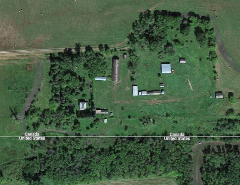
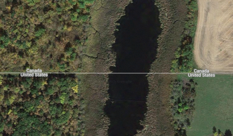
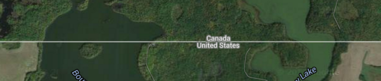
You might think, of course, that the U.S.-Canada border is just an imaginary line. But incredibly, that’s not true at all! Across the entire land border between the two countries, a 20-foot-wide treeless zone is cut.

The longest segment of the US- Canada border that doesn’t follow a river (in other words, a land border) is actually quite long: over 1200 miles, from Lake of the Woods (northern Minnesota) all the way west to the Vancouver area (Pacific Coast). That means that for over 1200 miles, there is a treeless zone.
And my idea is to hike it.
The Plan
Look, this isn’t just a hike that no one has ever attempted…it’s a hike that no one has ever thought of. Try searching for another article like this online, and you’ll find nothing.
Well, of course, that’s to be expected. It would be a crazy idea. For one, in the forest the clearing of trees is pretty apparent, but in the farmland you would need a really good GPS. For two, you would have to cross hundreds of miles of farmland, sometimes with incredibly close proximity to the owners of the property…
But then again, that’s the job of the International Boundary Commission, to do just that!… So, you know what I’m thinking the hiking outfits should look like?

Of course, getting lost and passing farmland wouldn’t be the only issues. Hikers would also have to look out for rivers, lakes, mountains, and a variety of other obstacles…
List of Obstacles
27 MILES IN:
Piney Pinecreek Border Airport. Has a runway in two countries. Looks flat enough to walk over, and that wouldn’t be abnormal, considering the farmer who works next door has probably done it too.

50 MILES IN:
The Roseau River (Caribou, MN) is 6 feet deep and 200 feet wide. Must be forded three times, but shouldn’t be too difficult.
I think that with a change of clothes and a waterproof backpack, hypothermia can be prevented. Otherwise this hike would end quickly.

64 MILES IN:
Some dirt field. Perhaps for lumber, judging by what look to be trees on the very top. Clearly crossable.

84 MILES IN:
The Red River of the North is about 15 feet deep, and 850 feet wide. That’s a 5 minute swim. A challenge, surely, but feasible.

129 MILES IN:
Pembina River. 5-10 feet deep, and less than 50 feet wide.

142 MILES IN:
Car junkyard.

202-235 MILES IN:
33 miles of North Dakota’s northern border will present a real challenge: 13 lakes will need to be crossed. These will total out to 16,850 feet, the longest being Ross Lake, almost a mile wide at 4,640 feet (a half hour swim). None of this is impossible by any standard, but it would require an above average level of swimming.


MILE 254:
Conundrum here. Which is better, swimming along the borderline and trying to cross whatever those two parallel lines are, or crossing at the maintenance road and fighting against whatever current the nearby dam creates? The choice is yours.

MILE 264:
The same gosh darn windy river crosses the border six times!

MILE 310:
Riviere du Lacs. 500 feet wide.
MILE 381:
Minnesota my ass. North Dakota is officially the land of Ten Thousand Lakes.

MILE 538:
Finally, some topography! Thanks Montana!

MILE 688:
Holy cow! The Milk River! 430 feet across, 3 crossings (and scrambling down a hillside). Should be dairy easy!
MILE 775:
Lakes like these can simply be walked around. No swimming necessary.

MILE 780:
Ah. My old friend, the Milk River. In a few miles, you’ll also have to ford the Boundary River and the Milk River’s northern fork.

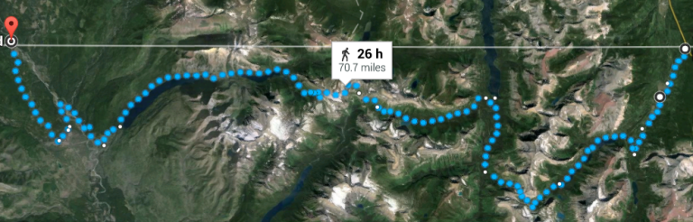
MILE 830-901:
Passing through Glacier National Park took me two hours worth of testing different routes. To sum up, the 49th parallel (the border) goes through a series of unclimbable mountains, and to get around them you would have to walk through dense forest with no trail. In the end, I decided to take trails within the national park (including the Pacific Northwest Trail) instead of going off trail, and then take a border service road back to the borderline. This way, you’ll see some of the best lakes, peaks, and sights that Glacier offers, plus you return to the border in time for the last, unobstructed, 26 miles of border within the limits of the national park!
MILE 933:
Kootenay River. Almost a mile wide. We can handle this.

MILE 989:
Foothills by Porthill, Idaho. Could be steep, probably walkable, considering someone had to cut those trees down.

MILE 1011-1013:
Avoid Snowy Top with 3 mile detour. Off trail, but avoids dense forest and sharp inclines.

MILE 1030:
Pend Oreille River. 450 foot swim.

MILE 1043:
Columbia River. 1430 foot swim (less than 9 minutes).

MILE 1068:
Kettle River. 210 foot swim.

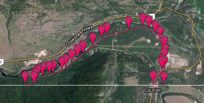
MILES 1069-1072:
You would have to climb a sheer cliff to continue on, so stand by me and take the train tracks until the border is on even ground…then cut through the trees to the borderline again. 4 mile detour.
MILE 1124:
Osoyoos Lake. Our longest swim yet, at 1.27 miles.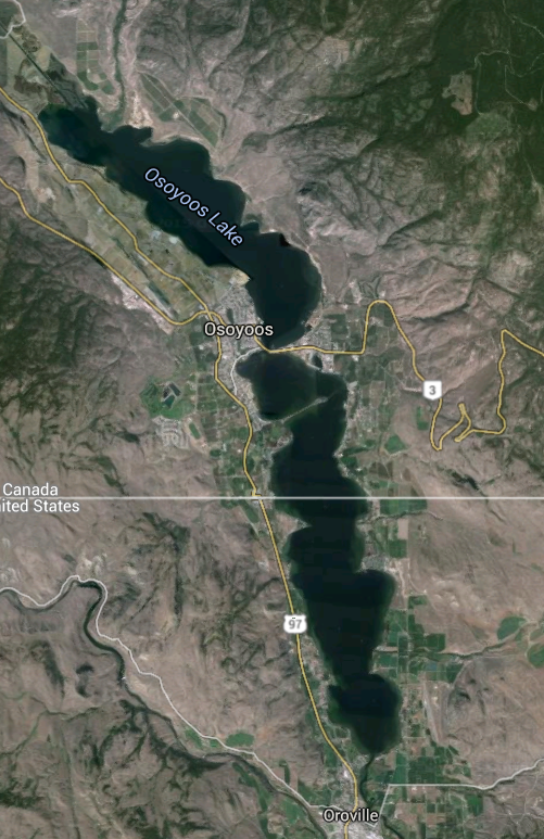
MILE 1157:
The deacon? Ah, live a little. Looks climbable.

MILE 1183-1184:
One mile detour. Tries to avoid dense trees and the steepest ascensions.

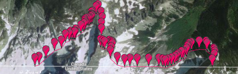
MILE 1198:
Swim across Ross Lake. 1.09 miles.

MILE 1203-1205:
Not necessarily a professional method to get by Mt. Rahm, basically eyeballing it. 2.5 mile detour. Unfortunately, I couldn’t find any online guidebook for this summit in particular…there was no Rahm e-Manual.
MILE 1216-1220:
Again, just eyeballing this 5.2 mile detour.

MILE 1221-1232:
Avoiding the Northern Cascades like a boss.

MILE 1280:
We finally finish, in Peace Arch State Park, on the Pacific Coast.

The Point of It All
Yeah. Pretty crazy isn’t it? The point of all of that “obstacle analysis” wasn’t really to be informational or to provide solid logistics…in the end, I only shared those obstacles and their potential reroutes to prove that this is feasibly possible to do. I mean, you could start in Minnesota and hike in the straightest line possible to Washington, for 1200 miles, on something that was never intended for hiking! And really, wouldn’t the scrambling and improvising (if done responsibly) be part of the fun?
At an average of 20 miles per day, this hike would barely take 2 months. And you know what? You’d be the first to do it.

CHECK OUT MY ATLAS OBSCURA ARTICLE ABOUT THE SLASH: http://www.atlasobscura.com/places/uscanada-border-slash

Just linked to you on FB!
https://m.facebook.com/story.php?story_fbid=10154538195437744&id=537982743
LikeLiked by 1 person
Awesome!
LikeLike
Amazing, something I certainly have not thought about. Those rivers would really add to the challenge.
LikeLike
The Slash was mentioned on a podcast and eventually i was like let’s hike the slash. Then i found this article. Thank you 😊
LikeLike
We recently completed a voyage that three of us took us to the northern, southern, eastern and western most point in the continental US. We also included the highest and lowest point in the lower 48 states – and chugged a beer while standing on our head at each of the six points. Now that we are done with that we have been thinking about hiking the entire 49th parallel along the border from Washington St. to Northern Angle. Saw your article and glad to see someone else is thinking about it.
We first thought about doing this about five years ago when we were at the Northern Angle which is the northern most point in lower 48. We could see the cut out in tree line in the distance while we were in the middle of the lake looking south.
Our plan would be to just hike as close to border as possible. We aren’t much for swimming so we plan on taking a canoe/kayak or some other meant to get across the lakes and rivers as necessary. We would plan to go west to east. We are hoping that once we get a couple hundred miles into the trip we may get some social media pr that we can parlay into making it a bit easier to go through some of the areas that are right along private property. We shall see. the journey is what its all about so won’t know until we start it.
Have you completed your hike yet.
LikeLike
Thanks for reaching out Tom! I actually have no personal experience doing such off trail hikes. These were just my best guesses as to how the logistics would work out. Please don’t take this as a comprehensive guide – make sure to be safe and do your own research first!
It’s absolutely awesome that you all are attempting this, and best of luck!!! Send me some photos / an article when you’re done!
LikeLike
the biggest obstacle that you would face would be legal. I live close to the border between Washington and British Columbia and have worked with government agencies on both sided. Virtually the entire length of the slash, even through semi-wilderness is saturated with cameras and motion detectors. Whichever direction you crossed you would seen be visited by patrols by land, water or air. Crossing the border at an unofficial location is not technically illegal in itself, but to conform to the law on such a proposed hike is completely impractical. To paraphrase, when you cross you must immediately report to the nearest port of entry before continuing on your trip. So each time you stepped south of 49 you would need to either backtrack or move directly to the port–you could not go into a town, camp etc. until doing so. If you go back north, same thing. The only way around it would be to obtain specific authority from both border agencies–no not the Int’l Boundary Commission–their only authority is to maintain the border, not to manage the people crossing it. Were you to wear that cap without authority, you would be tossed in the slammer. At the very local level (at least before 9/11 and all that) there were all sorts of local arrangements where in a town, ranch, farm or facility split by the border or where practical access was only through the other country there would be a wink and nod approach.
LikeLike
Dang!
Atlas Obscura taught me of the Slash, and now you’ve put me in mind to try!
(But Bradley Whitford and both I love you for the Rahm E-manual joke) 😝
DanCutter@gmail.com
LikeLiked by 1 person